Original OCR: no clean-up
15,397 ALTO XML files at page level
15,397 image files
METS metadata files at item level
2,340,799 lines and 3,514,177 words
Covers years 1855-1882
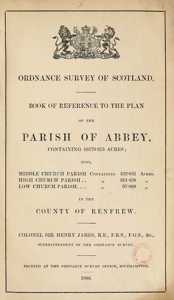
The Ordnance Survey Books of Reference (sometimes called ‘Area Books’, or ‘Parish Area Books’) were published between 1855-1882 to accompany the Ordnance Survey’s 25 inch to the mile maps. They record acreages of each land parcel shown on these maps and usually its land use (for example, categorising this as ‘arable’, ‘houses’, ‘gardens’, ‘woodland’). Collectively, they form the earliest, most complete estimate of land-use for the inhabited parts of Scotland in the 19th century. They also are the most complete estimate of the sizes of individual land parcels or fields across Scotland in the 19th century. Many of the Books of Reference record the names of the principal settlements and farms within each parish in a gazetteer at the end of each Book, and for each place, give references to the relevant Ordnance Survey 25 inch map these places fall on.
The Books of Reference were published for each civil parish, and they date from the time the relevant maps were surveyed for the relevant parish. The earliest volumes relate to the Borders and Central Belt from the late 1850s, and as the Ordnance Survey work generally moved north and east, the latest cover Orkney and Shetland from the late 1870s. Numbered land parcels on these Ordnance Survey 25 inch to the mile maps, listed consecutively within each parish, are included in the relevant parish Book of Reference. For volumes published after 1879, land-use information was often omitted, even though this information is generally available on the published Ordnance Survey 25 inch to the mile maps. In practice, for these volumes published after 1879, the distinction between arable, grass and market gardens is lost, but the maps still allow orchards, woodland and uncultivated ground to be distinguished by symbols on the maps.
Not all of the parishes of Scotland were covered by Books of Reference. There are two important limits to their coverage:
1. The Ordnance Survey’s 25 inch to the mile maps only cover about one-third of the total land area of Scotland: just the inhabited, cultivated regions. Upland, moorland, and sparsely populated areas do not have Books of Reference. The coverage also excludes six counties surveyed before 1855 (when the decision was taken by Ordnance Survey to adopt the 25 inch to the mile as the basic scale). These excluded counties, without Books of Reference are Edinburghshire, Fife, Haddingtonshire, Kinross-shire, Kirkcudbrightshire, Wigtownshire, and the Isle of Lewis. Land parcels in built-up areas and settlements are also excluded.
2. From 1855-1859, the Books of Reference were usually published as A0-sized lithographed sheets, which could be cut and bound into booklets. These sheets cover parishes in the following counties: Ayr, Berwick, Dumfries, Forfar (selected parishes), Lanark (selected parishes), Linlithgow, Peebles (selected parishes), Renfrew (selected parishes), Roxburgh (selected parishes). These sheets were not published as Books of Reference and so they are not in this data collection, but they can be viewed on the Library’s Ordnance Survey Books of Reference website.
Related links
Visit the Library’s Ordnance Survey Books of Reference website
View the Ordnance Survey 25 inch to the mile maps
View the Ordnance Survey Books of Reference in the Digital Gallery
Rights information

This collection is free of known copyright restrictions. For details visit the Library’s copyright page.
Download the data
Trial the data
Download a sample of the dataset for initial evaluation.
File contents: 1 plain text readme file; 742 ALTO XML files; 1 METS file; 742 image files.
File size: 69.4 MB compressed (95.6 MB uncompressed)
All the data
File contents: 1 plain text readme file; 1 CSV inventory file; 15,397 ALTO XML files; 22 METS files; 15,397 image files.
File size: 1.4 GB compressed (1.9 GB uncompressed)
Caution: large dataset
Just the text
File contents: 1 plain text readme file; 1 CSV inventory file; 22 plain text files.
File size: 6.1 MB compressed (21.4 MB uncompressed)
Cite the data
DOI: https://doi.org/10.34812/szks-7553
Dataset creator: National Library of Scotland
Dataset publisher: National Library of Scotland
Publication year: 2020
Suggested citation: National Library of Scotland. Ordnance Survey Books of Reference. National Library of Scotland, 2020. https://doi.org/10.34812/szks-7553