Download, explore and view records of 21,950 transcriptions and related information gathered from Ordnance Survey 25 inch to the mile maps of Edinburgh environs (1892-94).
This dataset contains records for 21,950 place names and related information gathered from Ordnance Survey 25 inch to the mile maps of Edinburgh environs (1892-94). Expanded and standardised forms of the transcriptions were created, and they were also categorised. The names were gathered through a crowdsourcing map transcription project between May and June 2022.
This was a collaborative project between the Alan Turing Institute and the National Library of Scotland, as part of the Machines Reading Maps project.
About the 25 inch mapping
The Ordnance Survey 25 inch maps are a standard topographic authority, depicting practically all human and natural features in the landscape with great accuracy. Every road, railway, field, fence, wall, stream and building is shown. All streets are named, including smaller terraces as well as named tracks and walks. Public buildings are named, including assembly rooms, churches, chapels, halls, hospitals, libraries, museums, post offices, railway stations, and schools. Many industrial and manufacturing premises and shown and named, as well as quarries and mines. There are also many features connected to water supply depicted, including conduits, pumps, drinking fountains and water taps. All public boundaries and administrative boundaries (including civil parish, municipal ward, burgh, and county boundaries) are clearly shown and named. The maps also include detailed numeric information: all land parcels are numbered along with their acreages, and there is detailed height information given in Bench Marks and Surface Levels. This was the earliest coverage of Edinburgh by Ordnance Survey at this scale. Read more about the OS 25 inch Edinburgh mapping
Purpose
The project aimed to transcribe all of the text on the Ordnance Survey’s 25-inch to the mile mapping for Edinburgh environs (1892-94). The primary aim of the project was to provide a detailed gazetteer of streets, buildings and names in Edinburgh from a century ago, to assist local and family historians. A secondary aim was to create an easy search interface of written features on the maps such as baths, drinking fountains, mills, public houses, signal posts, pumps, or wells, viewing the results as geographic distributions on a map. An important related aim has been to provide a test dataset for AI/machine learning approaches to identify text on maps, which are being actively developed. The OS 25 inch maps cover all inhabited areas of England, Scotland and Wales, and we are keen to encourage the wider extraction of text from these maps.
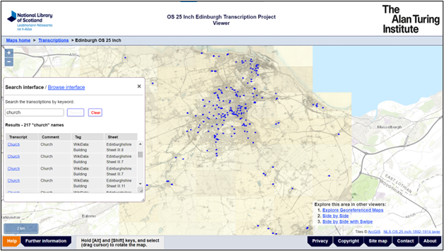
Searching the Edinburgh transcriptions
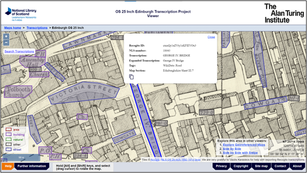
The Edinburgh transcriptions can be searched using a map interface. This allows a particular street name or keyword string to be queried, and a distribution map of the returned records to be displayed.
It is also possible to view all the textual transcriptions (ie. non-numeric transcriptions) as a browsable list. This shows all of the transcriptions as a single alphabetical sequence.
Transcriptions Field List
Raw dataset (Recogito download)
| Field name | Description |
|---|---|
| uuid | The unique ID for the transcription, generated by Recogito |
| transcription | The text transcription from the map |
| comments | A comment or expanded form of the transcription – for example, spelling out an abbreviation |
| tags | ‘area’, ‘street’, ‘building’, ‘natural’ or ‘other’, using WikiData URLs – see Tags |
| source | The map section that the transcription was from. For performance reasons in Recogito, we split our geographic area into ten separate map layers |
| anchor | Polygon coordinates as lat/lon (EPSG:4326) in Scalable Vector Graphics (SVG) format |
| group_id | The unique ID for grouped transcriptions |
| group_order | Sequential number of the transcription within a particular group_id |
Revised dataset (main Gazetteer)
| Field name | Description |
|---|---|
| uuid | The unique ID for the transcription, generated by Recogito. For items generated from a group of raw transcriptions, this is the Recogito group ID |
| transcription | The text transcription from the map |
| expanded_transcription | Expanded or standardised form of the transcription – for example, spelling out an abbreviation |
| tags | ‘area’, ‘street’, ‘building’, ‘natural’ or ‘other’ – see Tags |
| source | The map section that the transcription was from. For performance reasons in Recogito, we split our geographic area into ten separate map layers |
| WKT | Polygon coordinates as lat/lon (EPSG:4326) in Well Known Text (WKT) format |
| NLS_ID | The unique NLS ID in the corrected dataset |
| area | Area of the transcription polygon in square metres |
| text | ‘Y’ to indicate the transcription was a textual one. Blank if numeric |
| url | Link to the transcription in the Edinburgh transcriptions map viewer |
Related links
Explore the Edinburgh transcriptions viewer
Read more about the Tags in the Edinburgh transcriptions
Rights information

This data collection is licensed under a CC-0 license.
Download the data
Edinburgh OS 25 inch transcriptions data
Download the Edinburgh transcriptions dataset as CSV or GeoJSON files.