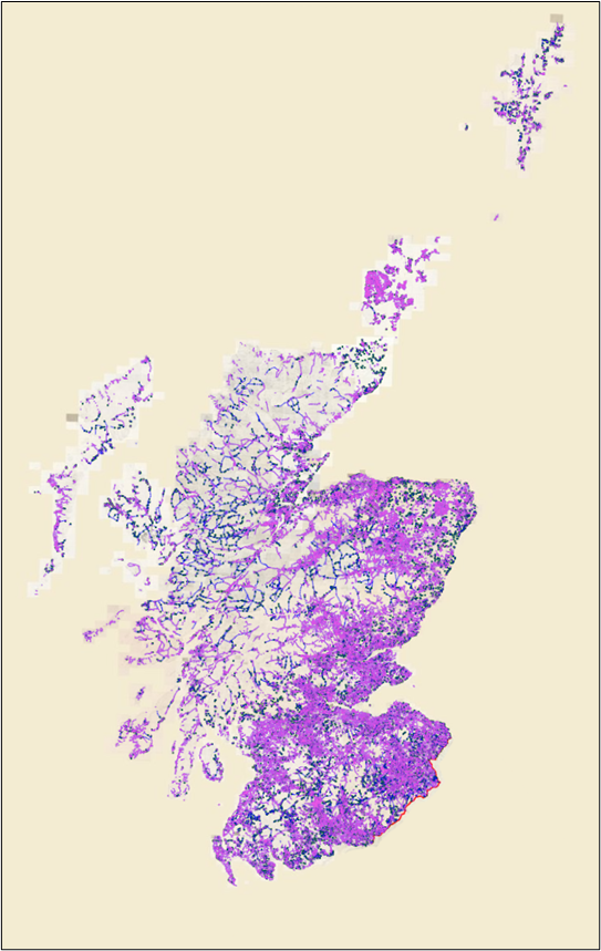
Download, explore and view records of over 120,000 footpaths traced from Ordnance Survey Six-Inch to the mile maps of Scotland (1888-1913).
This dataset contains records for 120,000 footpaths gathered from Ordnance Survey Six-Inch to the mile maps of Scotland (1888-1913). The footpaths are categorised into those which were labelled Footpath (F.P.) or Bridle Road (B.R.) and those which were not. The paths were traced through a crowdsourcing map transcription project between April and December 2022.
This was a collaborative project between Scotways (The Scottish Rights of Way and Access Society) and the National Library of Scotland.
About the OS Six-Inch mapping
The Ordnance Survey Six-Inch to the mile (or 1:10,560) County Series is the most comprehensive, topographic mapping covering of all of Scotland from the 1890s to the 1940s. The maps show most man-made and natural features in the landscape. Every road, railway, field, fence, wall, stream and building are shown, and smaller features such as letter boxes, bollards on quaysides, mile posts, and flag-staffs are also included too. Uncultivated land is distinguished by different symbols for marsh, bog, and rough grassland, types of woodland are distinguished (e.g., birch, fir, mixed, furze, osier, brushwood), as well as parks, ornamental grounds and orchards. All public boundaries and administrative boundaries (including civil parish, burgh, and county boundaries) are also clearly shown, apart from certain boundaries within towns. Spot heights in feet above mean sea level at Liverpool are shown along roads, railways, etc., and the six-inch maps are the most detailed scale at which contours are shown.
The more detailed 25 inch to the mile (or 1:2,500) maps which cover towns and other inhabited areas allow specific features to be seen more clearly, as well as greater detail for buildings and railways. However, most topographic features on the 25 inch to the mile maps are in fact also shown on the Six-Inch to the mile maps too. We used the 2nd edition of the Six-Inch to the Mile maps in this project, which were revised between 1888-1913. The georeferenced layer of these maps is made up of 7,486 paper map sheets, including 1,136 full sheets and 6,332 quarter sheets.
https://maps.nls.uk/transcriptions/paths/
Purpose
The primary aim of the project was to record paths and tracks shown on Ordnance Survey Six-Inch to the Mile maps of around 1900, to help facilitate Scotways’ work in researching the backgrounds of footpaths today and safeguarding them as rights of way. The initial focus of the project was therefore on recording paths and tracks which were specifically labelled as ‘Footpath’ (F.P.) or ‘Bridle Road’ (B.R.). However, as Ordnance Survey did not assign these abbreviations to many paths and tracks that were clearly footpaths, the scope of the project was widened to include and trace paths or tracks which did not have F.P. or B.R. abbreviations too. Sometimes more detailed Ordnance Survey 25 inch to the mile maps had these F.P. or B.R. abbreviations which were not generalised into the OS Six-inch maps which we were tracing. In addition, for various practical and legal reasons, Ordnance Survey was reticent in applying F.P. or B.R. abbreviations to many pedestrian or walkable routes which were shown on their maps.
However, the aim was not to trace all tracks or paths. Following the guiding purpose of assisting Scotways, we generally tried to exclude paths or tracks which were not intended for walking (such as firebreaks in woodland, tracks to quarries or refuse heaps, and private tracks leading to or around particular buildings). In general too, we tried to exclude routeways which were intended for motorised traffic. These were often described as being ‘metalled’, referring to the crushed small pieces of stone that formed part of the system of creating a levelled, sealed and waterproof road surface, as pioneered by John McAdam (1756-1836). Paths and tracks, by way of contrast, were usually on bare soil and described as ‘unmetalled’. These principles and exclusions are explained in more detail in the Path definitions section.
https://maps.nls.uk/transcriptions/paths/#zoom=15&lat=56.3473&lon=-3.2291
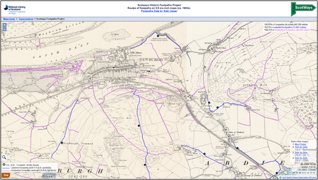
Viewing the Footpaths
The Footpaths can be viewed using a single-screen viewer or a split-screen viewer (Side-by-side).
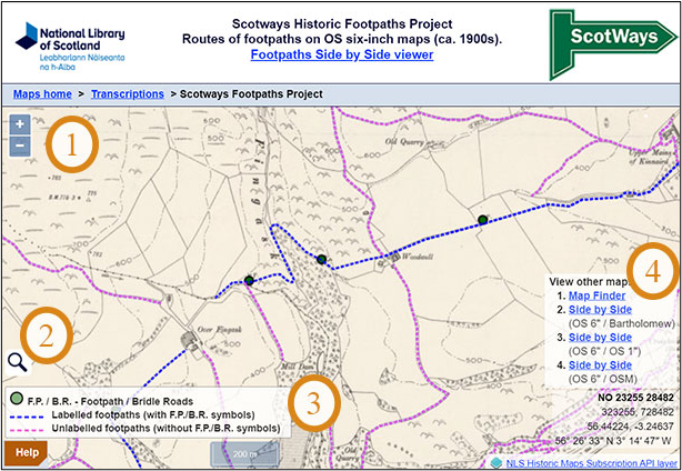
Number 1: Zoom in on an area with a mouse wheel, zoom buttons, double-click or pinch to zoom.
Number 2: Locate the map using a modern or historical place name search, or by historic counties/parishes (further information).
Number 3: The legend or key explains the colouring of the paths into labelled and unlabelled categories.
Number 4: Select the viewer links on the right to look at maps of the same area in other NLS map viewers.
Transcriptions Field List
| ID | The unique ID for the path, generated automatically as a sequential number |
| time | The date and time that the path was saved to the database |
| Unlabelled | YES for unlabelled paths – see Path definitions section for an explanation |
| length | length of the path in kilometres |
Related links
Historic Footpaths on the NLS Maps website: Explore the Historic Footpaths
Read more about the Historic Footpaths project
Rights information

This data collection is licensed under a CC-0 license.
Download the data
Historic Footpaths
Download the Historic Footpaths dataset as CSV or GeoJSON files.