Download, explore and view records of 33,523 place names and related information gathered from the Roy Military Survey of Scotland (1747-55).
This dataset contains records for 33,523 place names and related information gathered from the Roy Military Survey of Scotland (1747-55). The dataset includes all of the names on the Roy Military Survey, as well as place names from later Ordnance Survey 1st edition maps (1840s-1880s) that the Roy Map names relate to. The names were gathered through a crowdsourcing map transcription project by over 180 volunteers between February and July 2022.
This was a collaborative project between the British Library, who hold the original Roy mapping, and the National Library of Scotland.
About the Roy Map
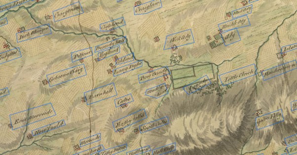
The Roy Military Survey of Scotland (1747-1755) is a uniquely important map in Scottish history and map-making. For many Highland areas, it is the most detailed and informative map that survives for the entire 18th century, whilst for all areas of the Scottish mainland, the only standard topographic map prior to the Ordnance Survey mapping in the 19th century. As well as being strikingly attractive to look at, the Roy Map is of value for researching many types of landscape history, including woodland, land-use, roads, settlements and antiquities.
Purpose
The primary aim of the project was to record all of the names on the Roy Military Survey. To aid searching and to improve the links with later Ordnance Survey maps, the name of a place either related to or nearby the Roy name was also transcribed from the OS one-inch and OS six-inch to the mile 1st edition maps (1840s-1880s).
The primary value of the Roy Map Gazetteer is that it allows a way of searching for particular places on the Roy Map. This is extremely useful for local and family history purposes, as well as for toponymic and placename research. As the Roy Map also includes descriptive names relating to features (such as bays, castles, cottar towns, kirks, harbours, mills, roads, or woods), the gazetteer also allows distributions of these particular features to be viewed.
Searching the Roy Map Gazetteer
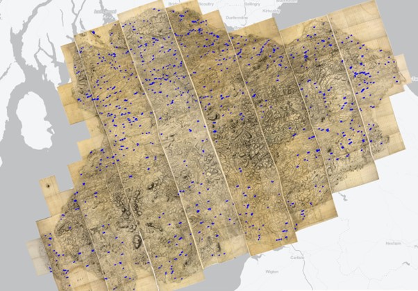
The Roy Map Gazetteer can be searched using a map interface. This allows a particular name or keyword string to be queried, and a distribution map of the returned records to be displayed. As the Roy Map is split into the Highlands and Lowlands, with an overlap between them, the map interface splits the gazetteer into the Highlands and Lowlands.
The Roy Map Gazetteer can also be searched as a browsable list. This shows all of the Roy Map names as a single alphabetical sequence, for both the Highlands and the Lowlands Roy Map layers.
Gazetteer Field List
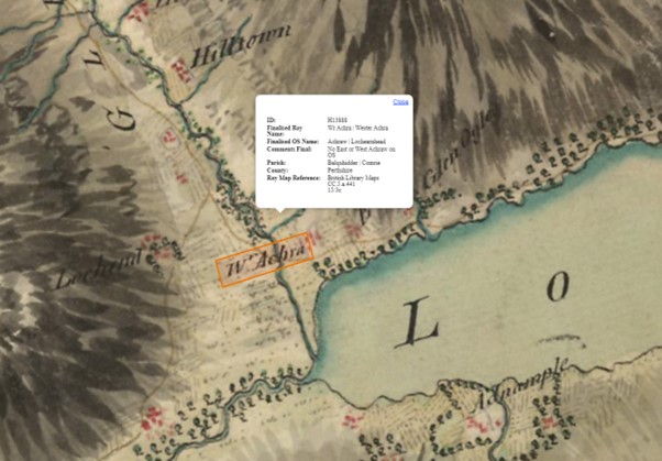
| ID | Unique ID for the entry. Prefixed with H (Highlands) or L (Lowlands) and a running number |
| RoyName | The exact name on the Roy Map – see https://maps.nls.uk/roy/gazetteer/#royname |
| OSName | The exact name on the OS 1st edition mapping – see https://maps.nls.uk/roy/gazetteer/#osname |
| Comments | Any additional notes about the names above, often to help with interpretation or for explaining the linkages between the Roy and OS Name |
| Parish | The parish the Roy Name was located in (1840s-1880s) |
| County | The county the Roy Name was located in (1840s-1880s) |
| Reference | The Roy Military Survey sheet dissection(s) the name falls on – see https://maps.nls.uk/roy/gazetteer/#reference |
Related links
Explore the Roy Military Survey website
Read more about the Fields in the Roy Map Gazetteer
Rights information

This data collection is licensed under a CC-0 license.
Download the data
Roy Military Survey Gazetteer
Download the Roy Military Survey Gazetteer dataset as CSV or GeoJSON files.