Chris Fleet (National Library of Scotland) mapped the distribution of quarry and colliery names across England, Scotland, and Wales from a century ago, using the GB1900 dataset.
Mapping and querying with QGIS
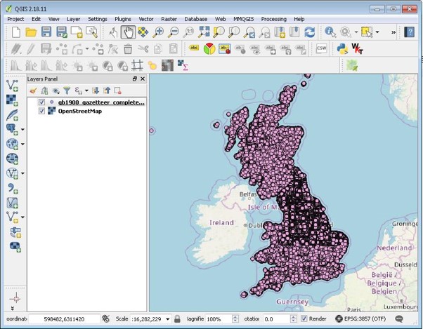
The GB1900 gazetteer is a set of 2.5 million named features, which were transcribed by volunteers from the Ordnance Survey’s six-inch to the mile maps, dating between 1888 and 1913.
One of the easiest ways of mapping and querying the GB1900 dataset is with a Geographic Information System like the free and open-source QGIS software. Once imported, one way of viewing this data is to set the layer to be shown on top of an OpenStreetMap map layer.
QGIS enables users to query or select the GB1900 gazetteer names using the ‘Query Attribute Table procedure’. For example, to query Quarry names, Chris selected these from the ‘final_text’ column, using a query string:
SELECT FROM gb1900_gazetteer WHERE (“final_text” LIKE ‘%Quarry%’) OR (“final_text” LIKE ‘% quarry%’)
This selects 44,222 names that have these text strings in them, and highlights the selected names on the map. The selected quarry names can also then be saved as a local shapefile or GeoJSON file, and opened on its own in QGIS.
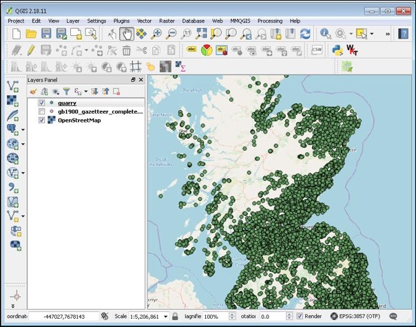
By applying the same workflow to extract colliery names, Chris also identified 3,042 collieries.
Viewing the results in an interactive web-mapping viewer
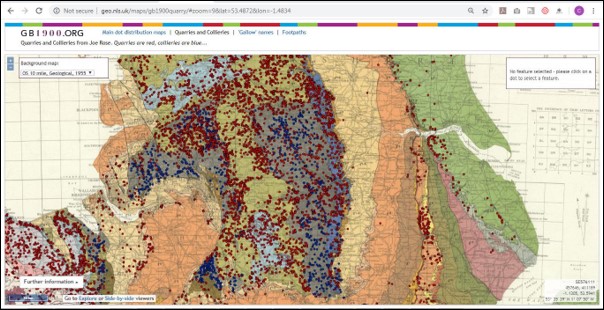
The next step was to set up these quarry and colliery names in an interactive web-mapping viewer showing quarry names in red and colliery names in blue. Although not all of these names relate to real world quarries or collieries, as they also include some names with these words within them, it is estimated that well over 95% of the point features shown relate to former or active quarries or collieries at the time these maps were produced, ca. 1888-1913.
If you keep zooming in beyond zoom level 14, the points should appear against a background Ordnance Survey six-inch to the mile map with the quarry or colliery named on the maps. You can also click on the red or blue dots to show the names and other information (including parish and county) associated with the feature.
It is also possible to toggle the background layer to display a 1950s geological map. It is not surprising to see that the distributions of quarries and collieries is closely linked to underlying geology.
The GB1900 gazetteer also includes names of farms, mountains, streets, villages, administrative areas, and more, (read further information about names on these maps) as well as Ordnance Survey abbreviations.
Find out more
View the GB1900 web mapping viewer: GB1900 quarries and collieries
Download the quarries data from this project: Quarries shapefile and GeoJSON file (6 MB compressed)
Download the collieries data from this project: Collieries shapefile and GeoJSON file (0.5 MB compressed)
More about the GB1900 data: A Vision of Britain Through Time website
Which dataset did this project use?
This project used the GB1900 gazetteer: GB1900 dataset on the Data Foundry website